Bristol’s rudest place name?
The other night conversation down the pub turned to Bristol place names.
Wherever one is, place names give a locality character. They commemorate local personalities, such as Mary Carpenter Place in Bristol’s St Pauls area, as well as national figures, e.g. Nelson Parade in Bedminster.
Others were named after the trades practised or goods traded on them. Bristol used to have a Milk Street and a Cheese Lane; it still has a Wine Street and a Corn Street, together with Old Bread Street.
Some street names are stranger and Bristol does not disappoint here either. There’s Zed Alley in the city centre, along with Counterslip down by the floating harbour. Counterslip is a corruption of Countess’ slipway, a reference to one of the long-vanished amenities on the then tidal River Avon of Bristol’s long-demolished castle.
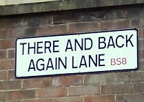 However, odd street names are not confined to Bristol’s centre. Up in Clifton one can find There and Back Again Lane, whose signs are a favourite target for the larcenous intentions of drunken student. Just beyond Durdham Downs, towards Stoke Bishop, is Pitch and Pay Lane. The origins of the lane’s name apparently hark back to times of plague when goods and money would be exchanged by being thrown across the thoroughfare.
Besides food and drink, other bodily needs are also commemorated. Along with other medieval towns and cities, once boasted a Grope Lane – to use the polite version – where ladies of negotiable affection were purported to ply their trade. The earliest written reference to Bristol’s Grope Lane I’ve found relates to 1433. It was previously known as Halliers Lane. Nowadays it’s better known as Nelson Street.
Besides streets and roads, fields also have names: and it is to one of these that one has to turn to find Bristol’s rudest place name – Fockynggroue.
Below is part of the abstract of a paper by linguistics professor Richard Coates of the University of the West of England (UWE):
The lost field-name Fockynggroue is recorded in the perambulation which constitutes the bulk of a Bristol charter conjecturally of 30 September (inspeximus 30 October), 47 Edward III, that is 1373. This document was drawn up when Bristol was granted county status.1 The field was in the region north(-west) of Brandon Hill between locations identifiable in modern times as Woodwell Lane and Crescent (names now lost, near and in St George’s Road) and Cantock’s Close.2 A. H. Smith, the editor of The Place-Names of Gloucestershire, offered no explanation, although he had obviously reflected on it because he classified it in the element-index as containing a ‘significant word’ (i.e. not a personal name), but without further elaboration.3 Perhaps he thought it too risqué to dwell on or too obvious to deserve comment, but, if so, he omitted to address a consequent issue in the lexical history of English. He did not cite the additional forms given in Bristol Charters.4 These are taken from perambulations of the city boundaries taken between the granting of county status and 1901: ‘Fukkyngroue, Pocking, Fokeing, Foking or Pucking Grove’. The name certainly lasted till around 1900, when a printed abstract of title for Hither & Inner Pucking Grove from 1707–1842 and a sale agreement of 1899 for the place were in existence.5
In modern times Fockynggroue has been diverted from its past as a location of carnal pleasures. Where it once helped generations of locals enjoy loving trysts and the pleasures of the flesh, it now caters for the intellect, having been built over as part of the campus of the University of Bristol.