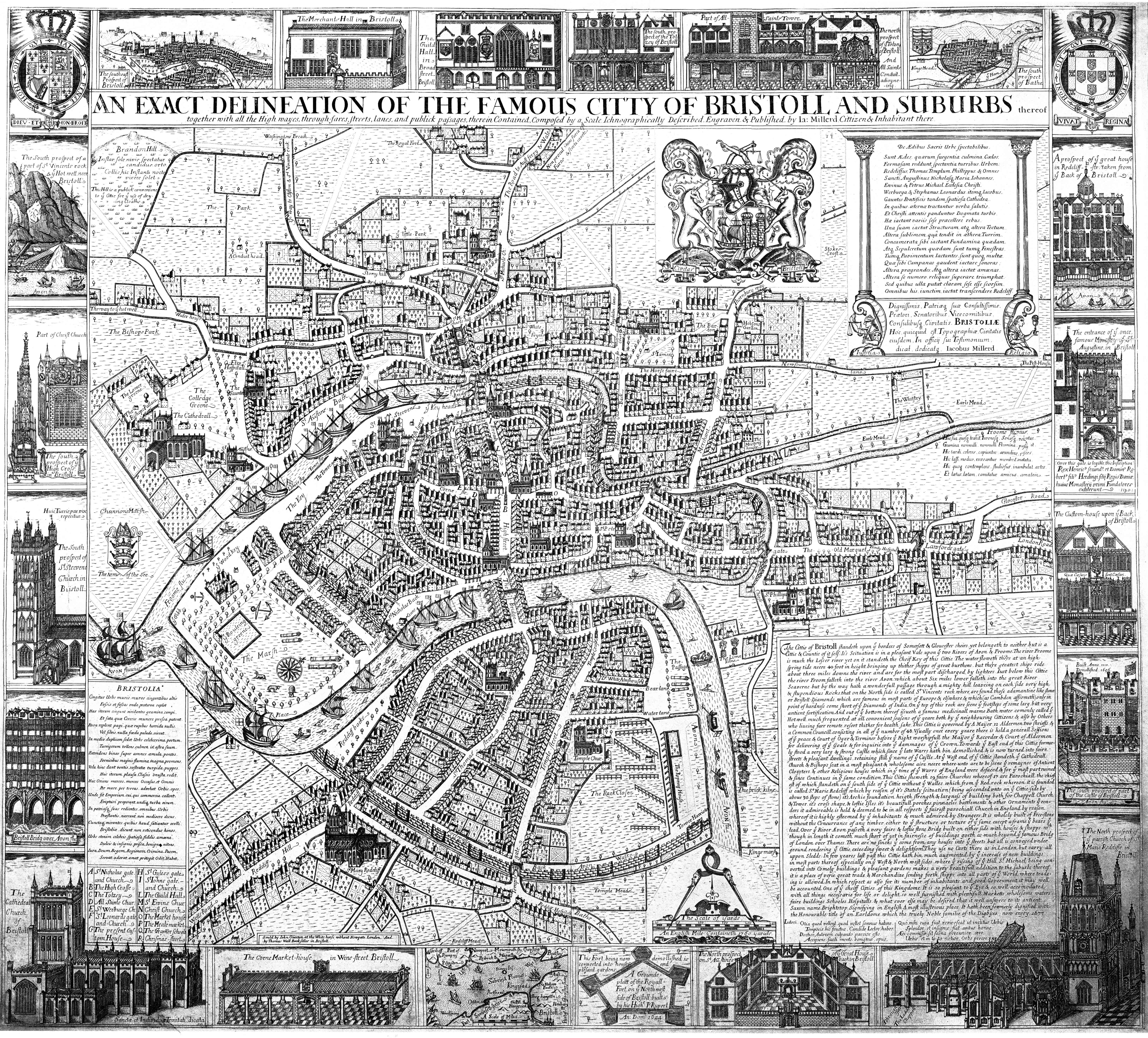
I’ve been very preoccupied recently with the history of Bristol (posts passim) and have now obtained a copy – in jpeg format – of James Millerd’s map of Bristol from the 1670s.

As a long-term resident of the city, several things strike me about the map: the city’s medieval walls appear to be largely intact, as are all the city gates (only one survives today in situ); the old four arch early medieval Bristol Bridge is there complete with housing and chapel; there’s no New Cut and Floating Harbour (i.e. port is still tidal); Bristol Castle may have gone, but its moat still remains and Brandon Hill looks like it gets a lot of use of washing days (This Hill is a publick convenience to ye Cittie for ye use of drying cloaths).
The text in the bottom right corner of the map makes particularly interesting reading and is reproduced below in the original 17th century English.
The Cittie of Bristoll standeth upon ye borders of Somersett & Gloucester sheirs, yet belongeth to neither but is a Cittie & Countie of itself. It’s seituation is in a pleasant Vale upon ye two Rivers of Avon & Froome. The river Froome is much the lesser river yet on it standeth the Cheif Key of this Cittie. The water floweth there at an high spring tide neere 40 foot in height bringing up thither shipps of great burthens, but there greatest ships ride about three miles downe the river and are for the most part discharged by lighters. Just below this Cittie the river Froom falleth into the river Avon which about Six miles lower falleth into the great River Seaverne but by the way hath a wonderfull passage through a mighty hill leaveing on each side very high & stupendious Rocks, that on the North side is called St Vincents rock where are found those adamantine like stones or Bristoll-Diamonds, which are famous in most parts of Europe & elsewhere & which (as Cambden affirmeth) only in point of hardness come short of ye Diamonds of India. On ye top of this rock are seene ye footsteps of some larg, but very antient fortification. And out of ye bottom thereof issueth a famous medicinall warme Bath water comonly called ye Hotwell, much frequented at all convenient seasons of ye yeare, both by ye neighbouring cittizens & also by Others, who liveing farr remote resort thither for health sake. This Cittie is governed by A Mayor, 12 Aldermen, two shrieffs & a Common Councill consisting in all of ye number of 48. Vsually once every yeare there is held a generall sessions of ye peace & Court of Oyer & Terminer before ye Right worshipfull the Mayor ye Recorder & Court of Aldermen for delivering of ye Goale & for inquirie into ye dammages of ye Crown. Toward ye East end of this Cittie formerly stood a very larg & strong Castle which since ye late Warrs hath bin demollished & is now turned into faire streets & pleasant dwelling retaining still ye name of ye Castle. At ye West end of ye Cittie standeth ye Cathedrall Church & Bishops seat in a most pleasant & wholesome aire neere where-unto are to be seene ye remaynes of Antient Cloysters & other Religious houses which in ye time of ye Warrs of England were defaced & for ye most part ruined & since continues in ye same condition. This Cittie sheweth 19 faire Churches whereof 17 are Parochiall, the chiefest of which standeth on ye south side of ye Cittie without ye Walles which from ye Red rock whereon it is founded is called St Marie Redcliff which by reason of it’s Stately seituation (being ascended unto on ye Cittie-side by above 30 steps of stone) it’s Archie foundation heigth strength & largeness of building, both for Chappell Church & Tower, it’s cross shape & loftie Isles, it’s beautifull porches, pinnacles, battlements and other Ornaments that renders it admireable, is held & deemed to be in all respects ye fairest parochiall Church in England by reason whereof it is highly esteemed by ye inhabitants & much admired by Strangers. It is wholly built of free-stone without the Concurrance of any timber either to ye structure or tecture of ye same that bears the lead. Over ye River Avon passeth a very faire & loftie stone Bridg built on either side with houses & shopps which though in length it cometh much short of yet in fairnesse of buildings goeth as much beyond ye famous Bridg of London over Thames. There are no sincks that come from any houses into ye streets, but all is conveyed under ground rendering ye Cittie exceeding sweet & delightsom. They use no Carts there as in London, but carry all uppon Sledds. In few yeares last past this Cittie hath bin much augmented by ye increase of new buildings in most parts thereof, especially on ye West & Northwest sides where ye riseing of ye Hill St Michael being converted in Comely buildings & pleasant gardens makes a very beautifull addition to the suburbs thereof; it is a a place of verie great trade & Merchandize sending forth shipps into all parts of ye World where tradeing is allowed. In which respect as also for its number of inhabitants and good Government it may well be accounted One of ye cheiff Citties of this Kingdome. It is so pleasant to ye Eye & so well accomodated with all things necessarie for life or delight, so well furnished with plentifull Marketts, wholesome waters, faire buildings, Schooles, Hospitalls & what ever else may be desired that it well answers to its antient Saxon name Brightstop, Signifying in English A most illustrious place. It hath been formerly dignified with the honourable title of an Earldome which the truely Noble familie of the Digbyes now enjoy. 1673.
As a linguist, what also intrigues me about the above description of the city apart from the erratic spelling and capitalisation is the presence of a large number of superfluous (or greengrocer’s) apostrophes; these are the earliest examples I’ve yet seen.
The full resolution (5,931 × 5,365 pixels (4.6 MB)) version of Millerd’s map is available from Wikimedia Commons.