Little bird, big name
The other afternoon I was having a rare afternoon pint in the shady garden of The Volunteer Tavern in St Judes when mine host Peter Gibbs asked me a question along the lines of: “What are these small brown birds I keep seeing in the garden?”
I told him that I’d frequently seen (and heard; as the RSPB remarks, “For such a small bird it has a remarkably loud voice.” Ed.) wrens in the garden.

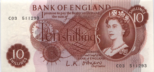
The wren is Britain’s smallest bird, measuring 9.5-10 cm, and used to feature on the back of Britain’s smallest coin – the pre-decimal farthing, which ceased to be legal tender after 31st December 1960.

Despite its small size, the wren has a big binomial name: Troglodytes troglodytes.
The wren is found across the UK in a wide range of habitats – woodland, farmland, heathland, moorland and islands and is a regular visitor to gardens, including pub gardens in central Bristol. 🙂
In European folklore, the wren is named the King of the Birds. According to a fable attributed to Aesop by Plutarch, when the eagle and the wren strove to fly the highest (presumably for the title of King of the Birds. Ed.), the wren initially rested on the eagle’s back and then when the eagle tired, the wren took off from his back, soared above him and so won the accolade.